


A new map shared by Trump is turning heads, with some unexpected countries now part of his America
This keeps getting worse.
On Jan. 20, 2026, Donald Trump posted an AI-generated image featuring a map with the U.S. borders expanded to include Canada, Greenland, Cuba, and Venezuela under the American flag. Now we can’t help but ask, can someone take away Trump’s AI subscriptions immediately, please?
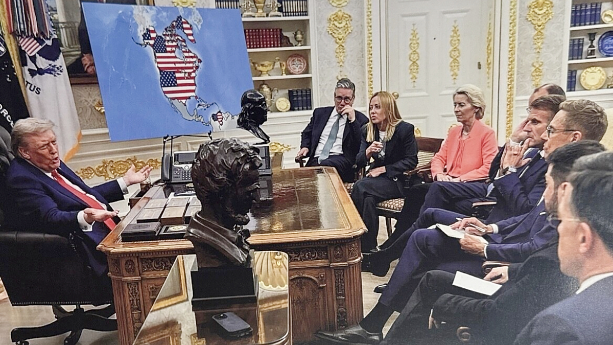
After first posting a deranged, shameless AI image of waving the American flag over Greenland at 1 a.m. on his Truth Social, Trump didn’t stop. He created and posted another AI image of him meeting with European leaders in the White House. The room included French President Emmanuel Macron, British Prime Minister Keir Starmer, and Italian Prime Minister Giorgia Meloni, among others.
But take a closer look, and the huge map of North America in the background would horrify you. Canada, Greenland, Venezuela, and Cuba were all painted in red, white, and blue. The American flag covers their existence as if the U.S. is entitled to it. And their sovereignty? Trump doesn’t recognize it anymore, apparently.
On its own, an altered map might look like internet trolling. But this wasn’t buried in a meme subreddit. This was posted by the sitting President of the United. The image was structured as if this “expanded America” were being casually presented amid diplomatic talks. There was no caption, no explanation, and no stated context. Just the image itself.
Outrage, disbelief, and fear took over social media
Across X and other platforms, the emotional response to Trump’s post was visceral. “No sane American president would ever post something like this. Impeach him before he starts WW3,” one wrote. “I just want to cry every time I see how he’s trashed the Oval Office,” another added.
One also suggested that we “start questioning this man’s mental health.” And truly, the post was too far-fetched, even for Trump. The public wasn’t just mocking the absurdity, but many saw it as a signal. One user described it as a psychological conditioning tactic used to normalize the idea of annexing sovereign nations:
This is a deliberate act of cartographic aggression. A map is a powerful political statement, and fabricating one that annexes allies’ territories is a symbolic act of conquest. It’s meant to visually implant the idea, test reactions, and gradually shift the Overton window to accept the unacceptable. This is how expansionist narratives are launched in the digital age.
Alarmingly, this wasn’t Trump’s first AI map moment. Minutes before posting this one, he posted a similar AI-generated image showing himself planting a U.S. flag on Greenland, labeling it “U.S. Territory — Est. 2026.” But this altered map post goes exponentially further by projecting U.S. dominion over multiple sovereign states.
At face value, an AI map is just image manipulation. But in a political context, maps are powerful narratives. They define imagined reality and influence collective perception. So, when the leader of a global superpower posts an image that suggests territorial control over multiple countries, it blurs the line between cartoonish fantasy and anticipated expansionist ambition.
Have a tip we should know? [email protected]
